Wednesday 28 June 2023

How to define Madden-Julian Oscillation? Unraveling the MJO : A Global Weather Phenomenon with Profound Impacts

By With No comments:
The Madden-Julian Oscillation (MJO) is a remarkable atmospheric phenomenon that influences weather patterns on a global scale. Named after its discoverers, Roland Madden and Paul Julian, this oscillation plays a crucial role in shaping regional climate variations, particularly in tropical and subtropical regions. In this article, we will delve into the intricacies of the Madden-Julian Oscillation and its impacts on weather systems worldwide.

How to define Madden-Julian Oscillation ?

The Madden-Julian Oscillation is characterized by an eastward propagation of enhanced and suppressed rainfall patterns across the tropical belt. It is often referred to as an "atmospheric heartbeat" due to its cyclical nature, typically spanning a period of 30 to 60 days. The MJO involves the interaction between atmospheric circulation, convection (rising air associated with thunderstorms), and atmospheric moisture.Understanding MJO Phases:

The Madden-Julian Oscillation is typically divided into two phases: an active phase and a suppressed phase. During the active phase, enhanced convection and rainfall occur over a particular region, promoting cloud formation and storm development. Conversely, the suppressed phase experiences reduced convection, leading to drier conditions and fewer storms.

The MJO exhibits an eastward progression, moving across the tropical belt from the Indian Ocean to the western Pacific Ocean. As it advances, it can influence weather patterns and precipitation in areas such as Southeast Asia, the Indian subcontinent, Australia, and even parts of North and South America.

Impact on Global Weather Patterns:

The Madden-Julian Oscillation significantly impacts weather systems around the world, producing both short-term and long-term effects. Some of its notable influences include:

Tropical Cyclone Activity: The MJO can intensify or weaken tropical cyclones, affecting their frequency, duration, and intensity. It can create favorable conditions for their formation by providing the necessary moisture and atmospheric instability.

Monsoon Seasons: The MJO has a profound impact on monsoon seasons in various regions, including the Indian subcontinent, Southeast Asia, and Australia. Its active phase can enhance monsoonal rainfall, while the suppressed phase may lead to drier conditions.

Temperature and Precipitation Patterns: The Madden-Julian Oscillation can influence temperature and precipitation patterns in both tropical and extratropical regions. Its effects can extend to areas far beyond the tropics, including parts of North and South America, Europe, and Africa.

El Niño and La Niña: The MJO can interact with larger-scale climate phenomena such as El Niño and La Niña. These interactions can either enhance or dampen the effects of these climate patterns, impacting global weather conditions.Forecasting the Madden-Julian Oscillation:

Efforts have been made to forecast the Madden-Julian Oscillation to improve weather predictions and climate modeling. Forecasting the MJO involves monitoring atmospheric variables such as wind patterns, moisture content, and cloud formations. This information aids in predicting its progression and potential impacts on regional weather conditions.

The Madden-Julian Oscillation is a fascinating atmospheric phenomenon with far-reaching impacts on global weather patterns. Its influence on tropical cyclones, monsoon seasons, temperature and precipitation patterns, and interaction with other climate phenomena highlights its importance in understanding and forecasting weather systems. By continuing to study the Madden-Julian Oscillation, scientists can enhance our ability to predict and respond to weather-related events, ultimately benefiting societies around the world.

Sunday 25 June 2023

Unlocking the Secrets of the Indian Ocean Dipole | Exploring its Impact on Climate and Monsoons

By With No comments:
The Indian Ocean Dipole (IOD) is a fascinating climate phenomenon that exerts a significant influence on weather patterns, particularly in the Indian Ocean region. It refers to the fluctuation in sea surface temperatures between the western and eastern parts of the Indian Ocean, impacting rainfall distribution and climate conditions. In this article, we will delve into the intricacies of the IOD, exploring its mechanism, effects on the monsoon, and broader implications for the region's climate.

Understanding the Indian Ocean Dipole

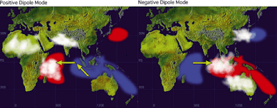
The IOD is characterized by two distinct phases: the positive phase and the negative phase. During the positive phase, the western Indian Ocean experiences warmer sea surface temperatures, while the eastern Indian Ocean remains relatively cooler. Conversely, the negative phase sees cooler waters in the western region and warmer temperatures in the east. These temperature anomalies trigger atmospheric changes that influence weather patterns over a vast geographical area.

Impact on the Monsoon

The Indian Ocean Dipole plays a vital role in modulating the strength and distribution of the Southwest Monsoon, which is the primary source of rainfall for India and neighboring countries. During the positive IOD phase, the warmer waters in the western Indian Ocean induce the ascent of moist air, leading to enhanced convection and increased rainfall in those areas. Simultaneously, the cooler eastern Indian Ocean suppresses convection, resulting in reduced rainfall over the eastern Indian subcontinent.

Conversely, the negative IOD phase flips this pattern, causing decreased rainfall in the western Indian Ocean and amplified rainfall in the eastern regions. These contrasting phases have a profound impact on agricultural activities, water resources, and overall socio-economic conditions in affected areas.


Wider Climate Implications

The Indian Ocean Dipole doesn't just influence the monsoon; it also impacts climate conditions across the Indian Ocean region and beyond. The temperature anomalies associated with the IOD affect atmospheric circulation patterns, which can trigger changes in global weather systems. The altered patterns of the IOD can impact phenomena such as the El Niño-Southern Oscillation (ENSO) and the Australian monsoon, creating far-reaching consequences.

Monitoring and Predicting the IOD

Accurate monitoring and prediction of the Indian Ocean Dipole are crucial for governments, meteorological agencies, and policymakers to prepare for potential impacts. Scientists use advanced climate models and satellite observations to track and predict the IOD's behavior, helping to provide early warnings and improve preparedness for the associated climate variations.

The Indian Ocean Dipole serves as a critical factor in shaping weather patterns, particularly the Southwest Monsoon, and has broader implications for climate conditions in the Indian Ocean region. Understanding the mechanisms and effects of the IOD is essential for effective climate forecasting, disaster management, and sustainable development. As scientists continue to study this intriguing climate phenomenon, it is our hope that enhanced knowledge will lead to improved predictions and better adaptation strategies to mitigate the impacts of the Indian Ocean Dipole.

Thursday 22 June 2023

Jetstreams and its power and influence : Exploring the Dynamics and Impacts of High-Speed Winds

By With No comments:
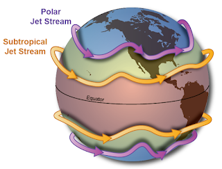
Jet streams, those invisible ribbons of powerful winds coursing through the atmosphere, have long fascinated scientists and aviators alike. These high-speed highways impact global weather patterns, influence flight routes, and play a crucial role in the dynamics of our planet. In this article, we delve into the captivating world of jet streams, uncovering their formation, characteristics, and significance, while exploring the ways they shape our lives.


Understanding Jet Streams

  • Introduction to Jet Streams: Discover the basics of jet streams, understanding them as narrow bands of strong winds flowing in the upper levels of the atmosphere. Learn how these wind currents differ from surface winds and delve into the factors that contribute to their formation, including temperature gradients and the Earth's rotation.
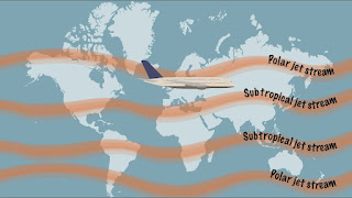
  • Types of Jet Streams: Explore the different types of jet streams, such as the polar jet stream and the subtropical jet stream. Understand their distinct characteristics, including altitude, speed, and seasonal variations. Delve into how these jet streams influence weather systems and air travel across the globe.

The Mechanics of Jet Streams

  • Jet Stream Formation: Dive into the intricacies of how jet streams are formed and the atmospheric dynamics behind their existence. Explore the Coriolis effect, pressure gradients, and temperature differentials as key factors contributing to the creation and maintenance of these high-speed winds.
  • Jet Stream Patterns: Uncover the typical patterns and behavior of jet streams. Discuss their meandering nature, jet streaks, and the concept of Rossby waves. Learn how these patterns affect weather systems, storm tracks, and the transport of heat and moisture across vast distances.

Impacts and Applications

  • Aviation and Jet Streams: Discover how jet streams impact aviation and flight routes. Explore how pilots strategically navigate these high-altitude winds to optimize fuel efficiency and reduce travel time. Discuss the benefits and challenges associated with flying with or against the jet stream.
  • Weather and Climate Influences: Examine the profound influence of jet streams on global weather patterns. Investigate their role in steering storm systems, influencing temperature gradients, and shaping seasonal weather phenomena. Discuss their impact on regional climates and long-term climate patterns.

Jet Stream Research and Future Insights

  • Studying Jet Streams: Highlight ongoing research efforts and technological advancements aimed at understanding jet streams better. Discuss the use of satellites, weather models, and atmospheric data collection methods to improve our knowledge of jet stream behavior and prediction.
  • Climate Change and Jet Streams: Address the potential impacts of climate change on jet streams and their implications for weather patterns and extreme events. Discuss scientific studies and theories that explore the relationship between a warming climate and the behavior of these powerful wind currents.

Jet streams are hidden marvels that shape our planet's weather and influence the way we traverse the skies. Their significance extends far beyond the bounds of aviation, reaching into the realms of climate dynamics and atmospheric science. By unraveling the mysteries of jet streams, we gain a deeper understanding of the intricate workings of our planet's atmospheric systems, inspiring us to appreciate the interconnectedness of the natural world and the influence these high-speed winds have on our daily lives.

Wednesday 21 June 2023

Kelvin Waves vs. Rossby Waves: Exploring the Key Differences and Dynamics

By With No comments:

Kelvin waves and Rossby waves are two types of atmospheric or oceanic waves that play significant roles in the dynamics of Earth's atmosphere and oceans. While they are both types of waves, they differ in their characteristics and the processes that drive them. Here are the key differences between Kelvin waves and Rossby waves:

  1. Nature and Propagation:

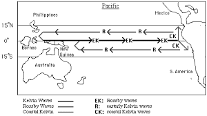
    • Kelvin Waves: Kelvin waves are primarily horizontally-propagating waves that occur in fluids with a free surface, such as oceans or the Earth's atmosphere. They are fast-moving, shallow-water waves that propagate along the equator or near the coastlines, driven by the interaction of the fluid with the underlying boundaries.
    • Rossby Waves: Rossby waves, also known as planetary waves, are large-scale, long-wavelength waves that occur in rotating fluids, such as the Earth's atmosphere and oceans. They have both a north-south and an east-west component of motion, and their propagation is influenced by the Coriolis effect due to the Earth's rotation. Rossby waves are slower and deeper than Kelvin waves.
  2. Wave Structure:

    • Kelvin Waves: Kelvin waves are typically characterized by a symmetric wave structure with no north-south motion. They propagate along coastlines or the equator, and their vertical motion is confined to the upper layer of the fluid.
    • Rossby Waves: Rossby waves have a more complex wave structure, including both east-west and north-south components. They can extend vertically through the entire depth of the fluid, and their wave crests and troughs are tilted with height.
  3. Driving Mechanisms:

    • Kelvin Waves: Kelvin waves are primarily driven by changes in the boundary conditions, such as changes in the coastline geometry or variations in the wind stress along the equator. For example, oceanic Kelvin waves can be triggered by wind bursts or changes in the trade winds.
    • Rossby Waves: Rossby waves are driven by the latitudinal variations in the Coriolis force and the meridional temperature gradients. They can be generated by processes such as baroclinic instability, topographic effects, or large-scale atmospheric disturbances like jet streams.
  4. Scale and Time Characteristics:

    • Kelvin Waves: Kelvin waves have shorter wavelengths and faster propagation speeds compared to Rossby waves. They typically have a period on the order of a few days to a couple of weeks and a horizontal scale of a few hundred to a few thousand kilometers.
    • Rossby Waves: Rossby waves have larger wavelengths and slower propagation speeds compared to Kelvin waves. They can have periods ranging from a few days to several weeks or even months, with horizontal scales spanning thousands of kilometers.


Both Kelvin waves and Rossby waves are important in shaping the large-scale weather patterns, circulation patterns in the oceans, and the transport of heat and momentum. Understanding their characteristics and dynamics is crucial for studying and predicting atmospheric and oceanic phenomena.

Tuesday 20 June 2023

Unveiling Hidden Shapes: Techniques to Identify Contours Within Contours

By With No comments:

Transforming points around a contour in an image can be done using image processing techniques such as geometric transformations. The specific steps to achieve this would depend on the type of transformation you want to perform and the nature of the contour and points. Here are some examples:

  1. Translation: To translate points around a contour, you can use matrix transformations such as a translation matrix. This can be done by first defining the translation vector, which specifies the amount of movement in the x and y directions, and then using matrix multiplication to translate the points.

  2. Rotation: To rotate points around a contour, you can use a rotation matrix. This matrix is determined by the angle of rotation and the center of rotation, which is typically the center of the contour.

  3. Scaling: To scale points around a contour, you can use a scaling matrix. The scaling matrix is determined by the scale factor in the x and y directions, and the center of scaling, which is typically the center of the contour.

  4. Affine Transformation: To perform an affine transformation, you can use a matrix that combines scaling, rotation, and translation. The matrix is determined by the transformation parameters and the center of transformation, which is typically the center of the contour.

It's worth noting that these transformations can be performed using image processing libraries such as OpenCV or scikit-image.

Related Posts Plugin for WordPress, Blogger...

Labels